A. Global Settlement: Patterns and Sustainability · Global Settlement: Patterns and SustainabilityHow the Environment Shaped Settlement: Egypt, Japan, Brazil and the Arctic
A1.1About 50 minutes
Learning goals- I can analyse how the physical environment has influenced settlement patterns in different countries and regions.
- I can explain why most Egyptians live along the Nile, why Japan's people crowd onto coastal plains, and why most Brazilians live near the Atlantic coast.
- I can describe how Inuit communities and builders adapt to the Arctic environment.
- I can use evidence to explain a settlement pattern.
Words to know
delta
Flat, fertile land at the mouth of a river, built up from soil (silt) the river carries and drops.
silt
Very fine particles of soil carried and dropped by moving water. It makes floodplains and deltas fertile.
irrigation
Bringing water to crops through canals, pipes or sprinklers.
coastal plain
Low, flat land beside the sea.
permafrost
Ground that stays frozen all year for at least two years in a row.
Inuit Nunangat
The Inuit homeland in Canada, which includes the Inuvialuit region, Nunavut, Nunavik and Nunatsiavut.
analyse
Break something into parts and explain how the parts are connected, using evidence.
Let's start with a question
Why are there so many high-rise towers in Hong Kong? Hong Kong is very hilly, with steep slopes coming down to the sea. There is little flat land, and millions of people need homes. So instead of spreading out, the city builds up. Some of its flat land was even made by filling in parts of the harbour.
In the last lesson you learned the physical factors that influence settlement. Now you'll analyse real countries and regions to see how those factors have shaped where people live.
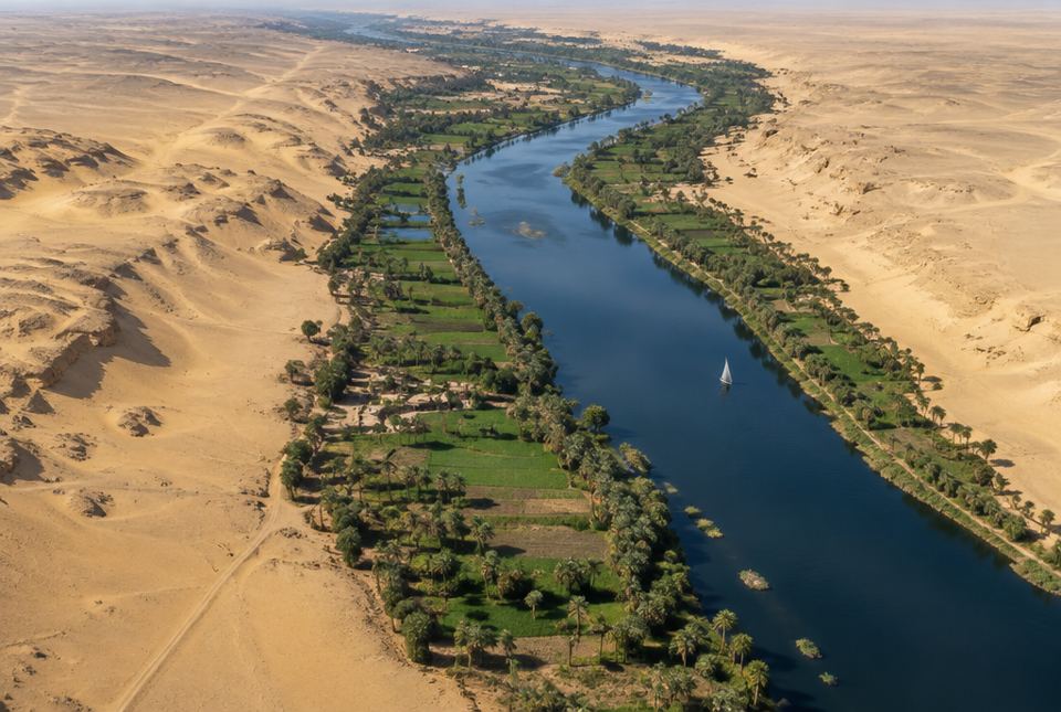 In Egypt, almost everyone lives in the thin green strip along the Nile. Notice how sharply the farmland ends where the desert begins. AI-generated image
Egypt: a river in the desert
Egypt is almost all desert, with very little rain. The Nile River flows north through the desert to the Mediterranean Sea. For thousands of years, the Nile flooded each summer and left behind fertile silt. With Nile water for irrigation and fertile soil, farmers could grow plenty of food in a narrow green strip along the river and in the wide delta.
As a result, the vast majority of Egyptians live in the Nile Valley and Delta, which make up only a small fraction of the country's land. Cairo, one of Africa's largest cities, is near the point where the river spreads out into the delta. Away from the river, the desert has very few people.
The Aswan High Dam, completed in 1970, now controls the floods and provides water for irrigation and electricity. But it also traps silt behind it, so farmers downstream rely more on fertilizer. Egypt is also building new cities in the desert, including a new capital east of Cairo, to ease crowding in the Nile Valley.
Japan: mountains and crowded plains
Japan is a country of islands. Roughly three-quarters of its land is mountains and hills, much of it forested. So most people live on the small coastal plains and in river valleys. The largest is the Kantō Plain, home to the Tokyo region, which the United Nations ranks as the world's largest urban area (about 37 million people in 2018).
Because flat land is scarce, Japanese cities are dense, farmers have built terraced fields on hillsides, and cities have reclaimed land from the sea. Japan also sits where tectonic plates meet (you learned about plates in Grade 7), so it has many earthquakes, tsunamis and volcanoes. Japanese cities use strict building codes, sea walls and warning systems.
Brazil: a coast-heavy pattern
Brazil is the largest country in South America. Most Brazilians live in the east, near the Atlantic coast, in large cities such as São Paulo and Rio de Janeiro. The coast has harbours for trade, and the southeast has fertile soils and a milder climate on higher land.
Much of northern Brazil is covered by the Amazon rainforest: hot, very wet, thickly forested and crossed by huge rivers. It is sparsely populated. Many Indigenous peoples live in the Amazon today, and riverside towns are spread along the rivers, which are the main highways. The city of Manaus grew on the Rio Negro near where it joins the Amazon, and much of its trade still travels by river.
In 1960, Brazil moved its capital inland from Rio de Janeiro to the newly built city of Brasília, partly to encourage people to settle the interior.
Canada's Arctic: adapting to a cold environment
Inuit have lived in the Arctic for thousands of years and have deep knowledge of its land, sea and ice. Today most people in Inuit Nunangat live in clustered communities on the coast. The sea and sea ice provide animals for hunting and fishing, and ships bring a year's supply of heavy goods (fuel, building materials, vehicles) during the short summer when the sea is open. Nunavut's communities have no road connection to southern Canada, so people and mail travel by air.
Much of the ground is permafrost. A heated building sitting directly on permafrost could melt the ice in the ground and sink or tilt, so many buildings are raised on piles (posts) with an air gap underneath. Water and sewage are often delivered and collected by truck in many communities, because pipes in frozen ground are costly and difficult to build.
| Place | Key physical factors | Resulting settlement pattern |
|---|
| Egypt | Desert climate; the Nile provides water and fertile silt | Most people in a narrow strip along the Nile and in its delta |
| Japan | Mountainous islands; small coastal plains; earthquakes | Very dense cities on coastal plains; reclaimed land; terraced hillsides |
| Brazil | Atlantic harbours and milder southeast; hot, wet rainforest in the north | Most people near the Atlantic coast; Amazon sparsely populated, with towns along rivers |
| Hong Kong | Steep hills; little flat land; deep harbour | High-rise towers; land reclaimed from the harbour |
| Canada's Arctic | Cold climate; permafrost; sea and sea ice | Clustered coastal communities; buildings on piles; sealift and air links |
Worked exampleExample: Let's analyse a settlement pattern
Explain why Hong Kong has so many high-rise towers. Use the steps geographers use to analyse.
- Describe the pattern: many tall residential towers, packed closely together.
- Identify the physical factors: steep hills, very little flat land, a coastal location with a deep harbour.
- Connect factors to the pattern: a harbour attracted trade and people, but there was little flat land for all of them. To fit many homes on a small amount of land, buildings go up instead of out. People have also reclaimed land from the sea to make more flat ground.
- Add evidence or a comparison: Japan's crowded coastal plains show a similar link between scarce flat land and high density.
Hong Kong's steep, hilly land leaves little flat space, while its harbour attracted millions of people. Building high-rise towers and reclaiming land let the city house many people on very little flat land.
Analyse, don't just list
A strong answer has three parts: the physical factor ("the Nile provides water in a desert"), the pattern ("most Egyptians live in a narrow strip along the river") and the connection ("because farming and drinking water are only possible where there is water"). Use the word because.
Hands-on activitySettle anywhere: a criteria challenge
You need: paper, a pencil, and a world atlas or online map.
- Imagine you could settle anywhere in the world. List five criteria for a good place to live (for example: fresh water, climate, flat land, jobs, safety from hazards).
- Rank your criteria from most to least important.
- Choose two real places from this lesson and give each a score out of 5 for each criterion. Add the scores.
- Write a short paragraph: Which place wins? Which physical factors made the biggest difference? Would a family member rank the criteria differently?
What to look for: criteria linked to physical factors (water, climate, landforms, soil, hazards) and a clear reason for the ranking. Different rankings are fine if they are explained.
Just for funHong Kong is so hilly that thousands of people ride an escalator to work. The Central–Mid-Levels escalator is about 800 m long and runs downhill in the morning rush and uphill the rest of the day. Topography wins again!
Your turn
1Why do the vast majority of Egyptians live along the Nile?
Egypt is mostly desert with very little rain. The Nile provides fresh water for drinking and irrigation, and its floods left fertile silt. So farming and settlement are possible mainly along the river and in the delta.
2Roughly how much of Japan is mountains and hills, and how does this affect where people live?
Roughly three-quarters. People crowd onto the small coastal plains and valleys, so Japanese cities are very dense.
3Where do most Brazilians live, and which large region is sparsely populated?
Most live in the east, near the Atlantic coast. The Amazon rainforest in the north is sparsely populated.
4Why are many buildings in Arctic communities raised on piles?
To keep the building's heat from thawing the permafrost underneath. If the frozen ground melted, the building could sink or tilt.
5Why did Brazil build Brasília and move its capital there in 1960?
Partly to encourage settlement of the interior, away from the crowded coast.
6Give one advantage and one challenge of the Aswan High Dam.
Advantage: it controls floods and provides irrigation water and electricity. Challenge: it traps silt, so farmland downstream gets less natural fertilizer.
7What is the main way heavy goods reach many Nunavut communities?
By ship (the sealift) during the short summer when the sea is open.
More practice: warm-up
Flat, fertile land at a river's mouth, built from silt the river drops.
2Which river flows through Egypt?
3On which large plain is Tokyo?
Ground that stays frozen all year for at least two years in a row.
5In which direction does the Nile flow?
North, to the Mediterranean Sea.
More practice: on your own
1Explain how topography shapes settlement in both Japan and Hong Kong.
Both have steep, mountainous or hilly land with little flat ground. People crowd onto the small flat areas, so settlements are very dense, buildings are tall, and both places have reclaimed land from the sea.
2Why are rivers so important for towns in the Amazon rainforest?
The thick forest makes road building hard, so the rivers are the main highways for travel and trade. Rivers also provide water and fish.
3Why do many Arctic communities have water delivered by truck instead of through pipes?
Pipes in permafrost must be protected from freezing and are costly and difficult to build, so trucks deliver water and collect sewage.
4Compare why people cluster in Egypt and in Canada's Arctic.
In Egypt, people cluster along the Nile because it is the only reliable water in a desert. In the Arctic, people cluster on the coast because the sea provides food and supply routes. In both, one key physical feature draws people together in a harsh environment.
5Rewrite this weak answer so it analyses: "Japan has mountains. Japan has dense cities."
For example: "Because roughly three-quarters of Japan is mountains and hills, people live mostly on the small coastal plains, so cities like Tokyo are very dense." (It links the factor to the pattern with because.)
Challenge
1Egypt is building new cities in the desert. Using physical factors, identify two challenges these cities face and one way to address each.
For example: Water: the desert has almost no rain, so water must be piped from the Nile or produced by desalination, and saved by reusing wastewater. Heat: very hot summers, so buildings need shade, insulation and efficient cooling. Soil: poor desert soil makes local farming hard, so food must be brought in or grown with careful irrigation. Any two challenges with sensible responses.
2A student says, "The physical environment decides exactly where people live." Do you agree? Use examples from this lesson.
Partly. The environment strongly influences settlement: Egyptians cluster on the Nile, and Japanese on the coastal plains. But people also make choices: Brazil built Brasília inland on purpose, and Hong Kong and Japan reclaimed land from the sea. Technology, governments and economics also matter, so the environment influences but does not completely decide.
3Choose two places from this lesson and explain which physical factor is most important in each, and why.
Example: Egypt: water is most important, because almost all farming and settlement depend on the Nile in a desert. Japan: topography is most important, because mountains limit settlement to small coastal plains. (Other well-supported choices, such as climate and permafrost in the Arctic, are also correct.)
Quiz
1. Why do most Egyptians live near the Nile?
2. Where do most people in Japan live?
3. Which region of Brazil is sparsely populated?
4. Why are many Arctic buildings raised on piles?
5. Why does Hong Kong have so many high-rise towers?
6. What was one effect of the Aswan High Dam (completed 1970)?
Big idea: A1.1 asks students to analyse some of the ways in which the physical environment has influenced settlement patterns in different countries and/or regions around the world. The curriculum's own examples include Egypt, Japan and Brazil; this lesson adds Hong Kong and Canada's Arctic.
Common difficulties:
- Listing instead of analysing. Push for the connection: factor + pattern + "because".
- Thinking the environment decides everything. Discuss human choices too (Brasília, land reclamation).
- Talking about Indigenous peoples in the past tense. Inuit communities and Indigenous peoples of the Amazon are living communities today.
How to help: Look at a satellite view of Egypt together: the green strip of the Nile in the brown desert is striking. Then compare Japan's mountains and plains. Ask, "If you lived there, where would you choose to live, and why?"