A. Global Settlement: Patterns and Sustainability · Global Settlement: Patterns and SustainabilityWhere People Live: Population Distribution and Density
A3.1About 45 minutes
Learning goals- I can explain the difference between population distribution and population density.
- I can calculate population density and compare places using it.
- I can describe where most of the world's people live and which regions have very few people.
- I can describe the pattern of where people live in Canada.
Words to know
settlement
A place where people live, from a single farm or a small hamlet to a huge city. Settlement also means the act of making a home in a new place.
population distribution
The pattern of where people live across an area: where they are crowded together, where they are spread out and where there is nobody at all.
population density
The average number of people living in a unit of area, usually written as people per square kilometre (people per km²).
densely populated
Having many people in a small area.
sparsely populated
Having few people spread over a large area.
square kilometre (km²)
The area of a square that is 1 km long on each side. A small town might cover a few square kilometres.
ecumene
The part of the land where people live permanently. Canada's ecumene is mostly a narrow band in the south.
Remember from Grade 7
In Grade 7 geography you studied the physical patterns of the world (landforms, water, climate and natural vegetation) and the world's natural resources. In Grade 8 the focus turns to people: where do people settle, why there, and how do their settlements affect the environment? Everything you learned about the physical world will help you answer those questions.
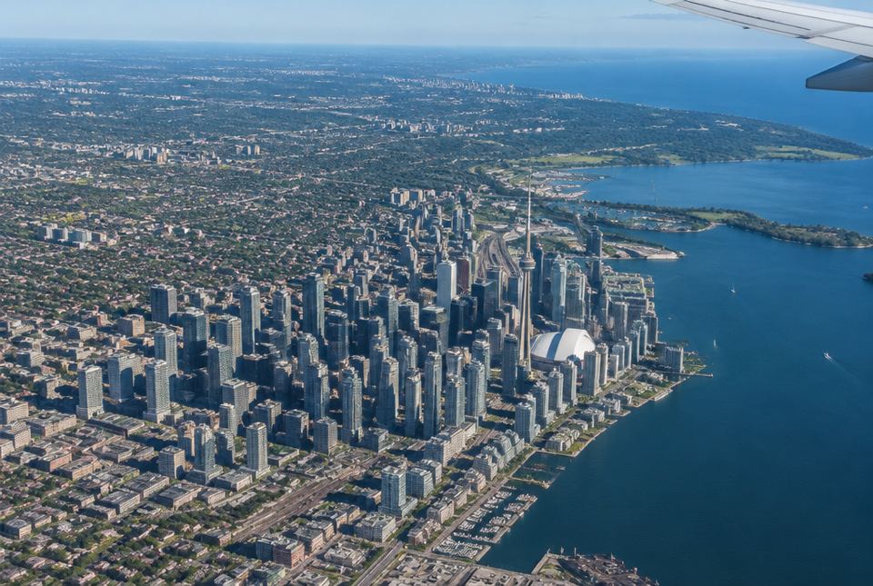 Where people live is not spread evenly. Near the centre of a big city, many people live on a small area of land, so the population density is very high. AI-generated image
Let's start with a question
The United Nations reported that the world's population passed 8 billion people in November 2022. Earth has roughly 149 million km² of land (counting Antarctica). If everyone were spread out evenly, there would be about 54 people on every square kilometre of land.
But people are not spread out evenly. Some places, like the centre of a big city, have thousands of people on every square kilometre. Other places, like the ice of Antarctica or most of the Sahara Desert, have almost nobody. Geographers want to describe this pattern and explain it.
Two different ideas: distribution and density
Population distribution describes the pattern: where are the people? Are they clustered in a few spots, lined up along a coast, or spread out evenly? You usually describe distribution in words or show it on a dot map.
Population density is a number: how many people live in each square kilometre, on average. You calculate it with a formula:
Population density = population ÷ area
The answer is in people per km².
A country can have a low density and still have most of its people crowded into a few cities. That is why geographers use both ideas.
Worked exampleExample 1: Calculate a population density
In the 2021 Census, Statistics Canada counted about 14.2 million people in Ontario. Ontario's land area is about 892 000 km². What is Ontario's population density?
- Write the formula: density = population ÷ area.
- Substitute: 14 200 000 ÷ 892 000.
- Simplify by dividing both numbers by 1 000: 14 200 ÷ 892 ≈ 15.9.
- Check that it is reasonable: 892 × 16 = 14 272, which is close to 14 200. ✓
Ontario has about 16 people per km².
| Place (2021 Census, Statistics Canada) | Population (about) | Land area (about) | Density (about) |
|---|
| Canada | 37 million | 8.8 million km² | 4 people per km² |
| Ontario | 14.2 million | 892 000 km² | 16 people per km² |
| Nunavut | 37 000 | 1.8 million km² | 0.02 people per km² |
| City of Toronto | 2.8 million | 631 km² | 4 400 people per km² |
The world pattern
When geographers map where the world's people live, some patterns stand out:
- Most people live in the Northern Hemisphere. Most of Earth's land is north of the equator.
- Four very large clusters: East Asia (eastern China, Japan and Korea), South Asia (India, Pakistan and Bangladesh), Europe, and eastern North America. Other dense areas include West Africa (for example, southern Nigeria), the island of Java in Indonesia and the Nile Valley in Egypt.
- People cluster near water: along coasts, on the shores of large lakes, and along rivers.
- People cluster on lowland plains and in river valleys with fertile soil and moderate climates.
The sparsely populated regions are places that are hard to live in or to farm:
- Very cold lands: the Arctic tundra, Antarctica and Greenland's ice sheet.
- Very dry lands: hot deserts such as the Sahara, the Arabian Desert and the interior of Australia.
- High, rugged mountains: the Himalayas, the Andes and the Rockies.
- Dense forests far from coasts, such as much of the Amazon rainforest and the boreal forest of northern Canada and Russia.
Sparse does not mean empty or unimportant. Many Indigenous peoples, including Inuit in the Arctic, live in and know these regions very well.
Canada's pattern
Canada is the second-largest country in the world by area, but its density is only about 4 people per km². That number hides a strong pattern. Statistics Canada reported that in 2016, two out of three Canadians (66%) lived within 100 km of the border with the United States, in a strip that covers only about 4% of Canada's land. The biggest cluster is in southern Ontario and southern Quebec, along the Great Lakes and the St. Lawrence River. Canada's ecumene (the area where people live permanently) is mostly a narrow band in the south, with communities spread across the North.
Watch out!
Density is an average. Nunavut's density is about 0.02 people per km², but that doesn't mean people live alone in the middle of the tundra. Nunavut's people live in 25 communities, most of them on the coast. The rest of the land has no permanent settlements, but it is still used for hunting, fishing and travel. Always ask: how are the people actually distributed?
Worked exampleExample 2: Compare two places
Pretend data: Riverton has 48 000 people on 240 km². Hillcrest has 9 000 people on 30 km². Which town is more densely populated?
- Riverton: 48 000 ÷ 240 = 200 people per km².
- Hillcrest: 9 000 ÷ 30 = 300 people per km².
- Compare: 300 is greater than 200.
Hillcrest is more densely populated, even though Riverton has more than five times as many people. A bigger population does not always mean a higher density.
Hands-on activityBean map: distribution and density
You need: a sheet of paper, a ruler, a pencil, a small handful of dried beans or pasta pieces (about 40). Keep small pieces away from young children, who could choke on them.
- Draw a large rectangle on the paper and divide it into 4 equal squares. Label them A, B, C and D. Pretend each square is 1 km² and each bean is 100 people.
- Draw a pretend river through squares A and B, and a pretend mountain range in square D.
- "Settle" your beans: place them where you think people would really choose to live. Put lots of beans near the river.
- Count the beans in each square and calculate each square's density (beans × 100 people per km²).
- Calculate the density of the whole map: total people ÷ 4 km².
- Write two sentences: one describing the distribution (where the beans are) and one comparing the densities.
What to look for: squares with the river should have the highest densities; the mountain square should have the lowest. The whole-map density is an average that hides those differences.
Just for funIf all 8 billion people stood shoulder to shoulder, about 4 people per square metre, everyone would fit into about 2 000 km². That's less than half the size of Prince Edward Island. Earth's crowding problem is about distribution, not running out of standing room!
Your turn
1In your own words, explain the difference between population distribution and population density.
Distribution is the pattern of where people live (clustered, spread out, along a coast). Density is a number: the average number of people per km².
2A town has 6 000 people living on 20 km². What is its population density?
300 people per km². 6 000 ÷ 20 = 300.
3Pretend data: Place X has 50 000 people on 250 km². Place Y has 9 000 people on 30 km². Which is more densely populated?
Place Y. X: 50 000 ÷ 250 = 200 per km². Y: 9 000 ÷ 30 = 300 per km².
4Name two kinds of physical environments where very few people live, and give a reason for each.
Any two, for example: very cold lands (the Arctic, Antarctica): short or no growing season and frozen ground; hot deserts (the Sahara): too little water for farming; high mountains (the Himalayas): steep slopes, thin air and little flat land; dense rainforest (the Amazon interior): hard to clear and travel through.
5According to Statistics Canada (2016), what share of Canadians lived within 100 km of the U.S. border?
6Name two of the world's large population clusters.
Any two of: East Asia (eastern China, Japan, Korea), South Asia (India, Pakistan, Bangladesh), Europe, eastern North America.
7Why can Nunavut's very low density (about 0.02 people per km²) be misleading?
Because it is an average. Nunavut's people live in 25 communities, mostly on the coast, so within each community people live close together. Most of the land has no permanent settlement.
More practice: warm-up
1Write the formula for population density.
Population density = population ÷ area.
2What units are usually used for population density?
People per square kilometre (people per km²).
31 000 people live on 10 km². What is the density?
100 people per km². 1 000 ÷ 10 = 100.
4True or false: a densely populated place has many people in a small area.
5What does sparsely populated mean?
Few people spread over a large area.
More practice: on your own
1A city has 1.2 million people on 600 km². What is its density?
2 000 people per km². 1 200 000 ÷ 600 = 2 000.
2A region has a density of 50 people per km² and a population of 25 000. What is its area?
500 km². Area = population ÷ density = 25 000 ÷ 50 = 500. (Check: 25 000 ÷ 500 = 50. ✓)
3Why do most of the world's people live in the Northern Hemisphere?
Because most of Earth's land is in the Northern Hemisphere. Much of the Southern Hemisphere is ocean, and the large southern landmass of Antarctica is covered in ice.
4Is this sentence about distribution or density? "Most people in Egypt live along the Nile River." Explain.
Distribution. It describes where people live (a pattern along the river), not a number of people per km².
5Give two physical reasons why many people live along coasts and rivers.
For example: fresh water for drinking and farming; fertile soil on river floodplains and deltas; transportation by boat; fish and other food; milder climates near large bodies of water.
Challenge
1Two pretend countries each have a density of 20 people per km². In Country A, people are spread fairly evenly over farmland. In Country B, almost everyone lives in one coastal city and the inland is desert. Explain why the same density can describe such different places, and what extra information a geographer would want.
Density is an average (population ÷ area), so it does not show distribution. Country B's coastal city would be extremely crowded while its desert has almost nobody, yet the average is the same as Country A's. A geographer would want a dot map or a choropleth map, or densities for smaller areas, to see where people actually live.
2Canada's density in 2021 was about 4.2 people per km². If Canada's population grew by 10% and its land area stayed the same, what would its density be?
About 4.6 people per km². The area is the same, so density grows by the same 10%: 4.2 × 1.1 = 4.62.
3The City of Toronto's density was about 4 400 people per km² in 2021, and Canada's was about 4.2. About how many times denser is Toronto? What does this tell you about Canada's population distribution?
About 1 000 times denser (4 400 ÷ 4.2 ≈ 1 048). It shows Canada's people are very unevenly distributed: a large share live crowded into cities in the south, while most of the land has very few people.
Quiz
1. What is population density?
2. A town has 8 000 people on 40 km². What is its density?
3. Which region is sparsely populated?
4. Which sentence describes population distribution?
5. Why is an average density sometimes misleading?
6. Where do many of the world's people choose to live?
Big idea: The Ontario curriculum (A3.1) asks Grade 8 students to identify significant spatial patterns in human settlement on a global scale, including population distribution and density. Students should be able to calculate density and describe the world pattern in their own words.
Common difficulties:
- Mixing up distribution and density. Distribution is a pattern (words, dot maps); density is a number.
- Dividing the wrong way (area ÷ population). Ask: "How many people for each km²?" People go on top.
- Thinking a low density means nobody lives anywhere. Use Nunavut's communities as an example.
- Large numbers. Divide both numbers by 1 000 first, and estimate to check.
How to help: Look at a night-time satellite image of Earth or a world population map online together and name the bright clusters. Ask, "Why do you think so many people live there?" The answers lead into the next lessons on settlement patterns and physical factors.