B. People and Environments · Political and Physical Regions of CanadaThe East: The Great Lakes–St. Lawrence Lowlands and the Appalachian Region
B3 B1About 40 minutes
Learning goals- I can describe the land, climate and vegetation of the Great Lakes–St. Lawrence Lowlands and the Appalachian Region.
- I can explain why so many Canadians live in the Great Lakes–St. Lawrence Lowlands.
- I can connect each region's land and water to the jobs people do.
- I can name First Nations who live in these regions and explain why treaties still matter.
Words to know
escarpment
A long, steep ridge or cliff.
St. Lawrence Seaway
Canals and locks that let ships travel between the Atlantic Ocean and the Great Lakes.
manufacturing
Making goods in factories.
erosion
When wind, water or ice slowly wears away land.
harbour
A sheltered place on the coast where boats can stay safely.
tide
The daily rise and fall of the ocean's water level.
Remember from Grade 3
In Grade 3 you learned that most people in Ontario live in the Great Lakes–St. Lawrence Lowlands, where the land is flat and the soil is fertile. Today you will follow these lowlands into Quebec, then keep going east to the Appalachian Region and the Atlantic Ocean.
The Great Lakes–St. Lawrence Lowlands
Where: southern Ontario and the land along the St. Lawrence River in Quebec.
Land: mostly flat or gently rolling, with deep, fertile soil. The Niagara Escarpment, a long rocky ridge, runs through southern Ontario. Niagara Falls pours over it.
Water: the Great Lakes and the St. Lawrence River. The St. Lawrence Seaway is a system of canals and locks that lets big ships travel all the way from the Atlantic Ocean into the Great Lakes.
Climate: warm, humid summers and cold, snowy winters. The Great Lakes keep nearby land a little warmer in fall and cooler in spring, and can bring heavy lake-effect snow.
Vegetation: mixed forests of maple, oak, beech and pine. Today, much of the forest has been cleared for farms and cities.
The busiest region in Canada
The Great Lakes–St. Lawrence Lowlands is the smallest of the main physical regions, but about half of all Canadians live here! Big cities include Toronto, Montréal, Ottawa, Quebec City and Hamilton.
Why so many people?
- Fertile soil and a long growing season for farms: fruit in the Niagara area, vegetables, corn, soybeans and dairy farms.
- Maple syrup: Quebec makes most of the world's maple syrup.
- Water for transportation: ships carry goods on the lakes, the river and the Seaway.
- Factories (manufacturing) that make cars, airplanes, food and much more. Factories are near workers, roads, railways and ports.
- Lots of services: hospitals, universities, banks, stores and governments (both Ottawa and Quebec City are here).
Peoples of the Lowlands
These lowlands are the homelands of many nations who live here today:
- Haudenosaunee nations, such as the Mohawk at Akwesasne, Kahnawà:ke and Tyendinaga, and the Six Nations of the Grand River in Ontario, the First Nation with the most members in Canada.
- Anishinaabe nations, such as the Mississaugas of the Credit First Nation.
- The Huron-Wendat Nation at Wendake, beside Quebec City.
The Haudenosaunee have grown corn, beans and squash together, known as the Three Sisters, for many hundreds of years, and many families still grow them.
The Appalachian Region
Where: New Brunswick, Nova Scotia, Prince Edward Island, the island of Newfoundland, and south-eastern Quebec (including the Gaspé Peninsula).
Land: The Appalachians are very old mountains. Over hundreds of millions of years, wind, rain and ice wore them down. This slow wearing away is called erosion. Now they are low, rounded mountains and hills, with river valleys and long, rocky coastlines with bays and coves. Prince Edward Island is fairly flat, with red soil (it is red because of iron in it).
Climate: The Atlantic Ocean makes winters a bit milder than inland, but the region gets lots of rain and snow, strong storms, and fog along the coast.
Vegetation: mixed forests of spruce, fir, maple and birch.
Living and working in the Appalachian Region
- Fishing: lobster, crab, scallops and other seafood. Many towns grew up around harbours.
- Farming in fertile valleys and on Prince Edward Island: potatoes (PEI is famous for them), apples in Nova Scotia's Annapolis Valley, blueberries and dairy.
- Forestry: New Brunswick has large forests.
- Tourism: visitors come for the coast, lighthouses, and the Bay of Fundy, which has the highest tides in the world.
- Cities include Halifax, St. John's, Moncton, Saint John, Fredericton and Charlottetown.
Mi'kmaq (Mi'kmaw) communities live throughout Nova Scotia, Prince Edward Island, New Brunswick, Quebec's Gaspé and Newfoundland. Wolastoqiyik (Maliseet) communities live along the Wolastoq (Saint John River) and Peskotomuhkati (Passamaquoddy) people live in New Brunswick. Long ago, these nations signed Peace and Friendship Treaties with the British. These treaties did not give up land. In 1999, the Supreme Court of Canada agreed that the treaties protect their right to fish to earn a modest living.
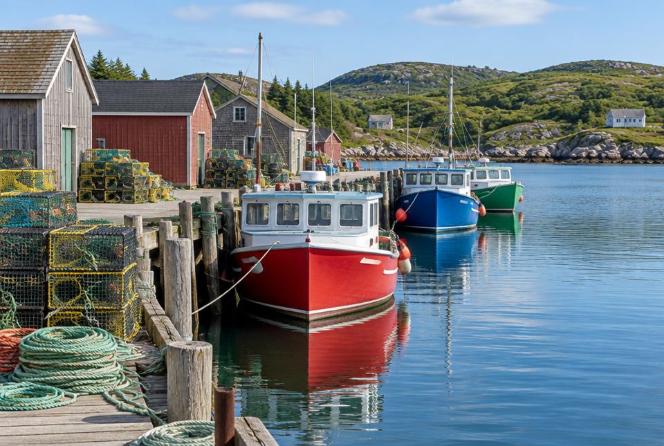 A fishing harbour in Atlantic Canada. Look for the stacked lobster traps on the wharf: fishing is an important job in the Appalachian Region. AI-generated image
Just for funThe Bay of Fundy has the highest tides in the world. A fishing boat floating at the dock at high tide can be sitting on the mud a few hours later. Talk about a boat that's "grounded"!
| Great Lakes–St. Lawrence Lowlands | Appalachian Region |
|---|
| Land | Flat or gently rolling, fertile | Low, rounded mountains, hills, coastlines |
| Climate | Warm, humid summers; cold, snowy winters | Ocean climate: lots of rain and snow, fog, storms |
| Vegetation | Mixed forest (much now farms and cities) | Mixed forest |
| Main activities | Farming, manufacturing, shipping, services | Fishing, farming, forestry, tourism |
Worked exampleLet's explain where people live
Why do so many Canadians live in the Great Lakes–St. Lawrence Lowlands?
- Land: it is flat, so it is easy to build homes, roads and railways.
- Soil and climate: fertile soil and warm summers grow lots of food.
- Water: the lakes and river give drinking water and a highway for ships.
- Jobs: factories, offices, ports and governments attract workers.
Flat land, fertile soil, a milder climate, lots of water and many jobs draw people here.
Worked exampleLet's connect the ocean to jobs
Why are there so many fishing towns in the Appalachian Region?
- Look at a map: most of the region is beside the Atlantic Ocean, with long coasts.
- The ocean has lots of seafood like lobster, crab and fish.
- Bays and coves make sheltered harbours for boats.
Long coasts, sheltered harbours and rich ocean waters made fishing a big part of life.
Hands-on activityOld mountains, young mountains
You need: two small lumps of play dough or modelling clay, a bowl or tray, and a cup of water. A grown-up should be nearby.
- Shape both pieces into tall, pointy mountains. One is the young Cordillera, and one is the old Appalachians.
- Put the "Appalachian" mountain in the tray. Drip water on it slowly with your fingers, like rain. Rub it gently with your thumb, like wind and ice.
- Keep going for a few minutes. What happens to its shape?
- Compare it with the "Cordillera" mountain, which you left alone.
- Tell a grown-up why the Appalachians are now low and rounded.
What to look for: Your child explains that rain, wind and ice wear mountains down over a very long time, so older mountains are lower and rounder.
Your turn
1About how many Canadians live in the Great Lakes–St. Lawrence Lowlands?
About half of all Canadians.
2Name two big cities in the Great Lakes–St. Lawrence Lowlands.
Any two: Toronto, Montréal, Ottawa, Quebec City, Hamilton.
3What is the St. Lawrence Seaway?
A system of canals and locks that lets big ships travel from the Atlantic Ocean into the Great Lakes.
4Why are the Appalachian mountains low and rounded?
They are very old, and wind, rain and ice have worn them down over a very long time.
5Name two jobs in the Appalachian Region.
Any two: fishing, farming (potatoes, apples), forestry, tourism.
6Which bay has the highest tides in the world?
7Name one First Nation of the Atlantic provinces.
Any one: Mi'kmaq, Wolastoqiyik (Maliseet), Peskotomuhkati (Passamaquoddy).
More practice: warm-up
1Is the soil of the Great Lakes–St. Lawrence Lowlands fertile or thin?
2What crop is Prince Edward Island famous for?
3Which ocean is beside the Appalachian Region?
4Which province makes most of the world's maple syrup?
5What are the Three Sisters?
Corn, beans and squash, grown together.
More practice: on your own
1Why is there so much manufacturing (factories) in the Great Lakes–St. Lawrence Lowlands?
There are many workers (lots of people), roads, railways and ports to move goods, and water for shipping. Factories also sell to the many people who live nearby.
3Compare the climate of Toronto and Halifax in winter. Which is likely more foggy and stormy, and why?
Halifax, because it is right on the Atlantic Ocean, which brings storms, fog and lots of rain and snow.
4Most of the forest in the Lowlands has been cleared. What replaced it?
Farms and cities (homes, roads, factories).
5What did the Supreme Court of Canada agree about in 1999 for the Mi'kmaq, Wolastoqiyik and Peskotomuhkati?
That their Peace and Friendship Treaties protect their right to fish to earn a modest living.
Challenge
1The Great Lakes–St. Lawrence Lowlands has the best farmland in eastern Canada, but cities keep growing onto farms. Why is this a problem? What could people do?
Good farmland is rare, and once it is covered by houses and roads, it can't easily be used for farming again. We would grow less food close to home. People could build up (apartments) instead of out, protect farmland with rules (like Ontario's Greenbelt), and reuse old empty land in cities.
2Both regions in this lesson are beside lots of water. Explain how water helps people in each region in a different way.
Lowlands: the Great Lakes and St. Lawrence give drinking water and a shipping route for factories and farms. Appalachian: the Atlantic gives seafood for fishing, and coasts attract tourists.
3Why do you think Peace and Friendship Treaties, signed long ago, still matter today?
Treaties are agreements that still count today. They shape rights (like fishing), how land and resources are shared, and how First Nations and Canada work together. Keeping promises matters.
Quiz
1. Where do about half of all Canadians live?
2. Why are the Appalachians rounded?
3. Which job fits the Appalachian Region best?
4. What lets big ships sail from the Atlantic into the Great Lakes?
5. Which province is famous for potatoes and red soil?
6. Which nation lives at Wendake, beside Quebec City?
Big idea: The Great Lakes–St. Lawrence Lowlands are small but home to about half of Canadians because of flat land, fertile soil, a milder climate, water routes and jobs. The Appalachian Region has old, worn-down mountains and long Atlantic coasts, and its jobs (fishing, farming, forestry, tourism) are tied to land and sea. First Nations in both regions have treaty relationships that still matter today.
How to help at home:
- Look at a population map of Canada and notice how many people live along the Great Lakes and the St. Lawrence River.
- Read labels: PEI potatoes, Nova Scotia apples, Quebec maple syrup, Ontario fruit and vegetables.
- If you live in southern Ontario, look for farmland, the Niagara Escarpment, or Great Lakes shorelines on outings.
Common difficulties:
- Mixing up the two "lowlands" regions. The Great Lakes–St. Lawrence Lowlands are in the south with farms and big cities; the Hudson Bay Lowlands are wet and northern.
- Thinking the Appalachians are not mountains. They are real mountains, just very old and worn down.
Safety: The mountain activity is safe, but stay nearby if younger children are around (small pieces of play dough).