B. People and Environments · Political and Physical Regions of CanadaThe West: The Cordillera and the Interior Plains
B3 B1About 40 minutes
Learning goals- I can describe the land, climate and vegetation of the Cordillera and the Interior Plains.
- I can explain how the land and climate connect to jobs in each region.
- I can name some First Nations and the Métis Nation who live in these regions.
- I can compare two physical regions.
Words to know
mountain range
A long row of mountains.
temperate rainforest
A forest with lots of rain and mild temperatures, like the B.C. coast.
prairie
Flat or rolling grassland.
fertile
Rich and good for growing crops.
ranching
Raising cattle or other animals on large areas of land.
chinook
A warm, dry winter wind in southern Alberta.
Métis
A distinct Indigenous people with its own culture, language (Michif) and homeland, including the Prairies.
A trip west
Imagine taking a train west from Winnipeg. For a whole day you see flat land, wheat fields and big skies. Then, past Calgary, the Rocky Mountains rise up like a wall. Two neighbours, two very different regions: the Interior Plains and the Cordillera.
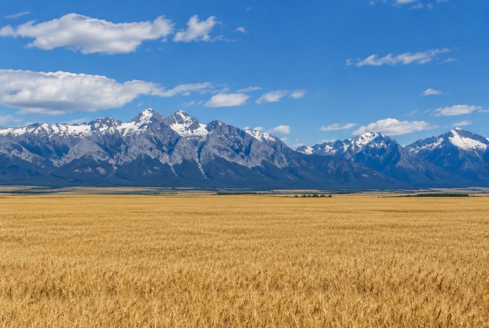 Two neighbours: the flat farmland of the Interior Plains, and the Rocky Mountains of the Cordillera rising up like a wall. AI-generated image
The Cordillera: Canada's mountains
Where: most of British Columbia and Yukon, the western edge of Alberta, and part of the Northwest Territories.
Land: many mountain ranges with deep valleys, plateaus and fast rivers. The Rocky Mountains run along the British Columbia–Alberta border. The Coast Mountains run along the Pacific. Canada's highest mountain, Mount Logan (5959 m), is in Yukon.
Climate: It changes a lot from place to place.
- On the coast, winters are mild and it rains a lot.
- Higher up the mountains, it is colder, and snow can stay all year on the highest peaks.
- Inland, behind the mountains, it is drier.
Vegetation: On the rainy coast grows a temperate rainforest with giant trees like western red cedar, Sitka spruce and Douglas fir. Inland there are forests, and dry grassy valleys in some places.
Living and working in the Cordillera
The land shapes the jobs:
- Forestry: the huge trees are cut for lumber and paper.
- Mining: the mountains hold minerals such as copper, gold and coal.
- Fishing: salmon swim up rivers like the Fraser River, and boats fish in the Pacific.
- Tourism: people come to ski, hike and visit parks like Banff National Park, Canada's first national park.
- Hydroelectricity: fast mountain rivers are used to make electricity.
- Shipping: the Port of Vancouver is Canada's biggest port. Ships carry goods across the Pacific to Asia.
Most people live in the valleys and along the coast, where the land is flatter, like Vancouver and Victoria. Steep mountains make it hard to build roads and towns.
First Nations of the Cordillera
British Columbia has more than 200 First Nations, more than any other province, each with its own territory, and many with their own languages. For example:
- The Haida Nation lives on Haida Gwaii, islands off the north coast. Haida artists are famous for carving cedar into poles and canoes.
- For many nations along the coast and rivers, salmon is very important for food, culture and ceremonies, today as it was long ago.
In Yukon, many First Nations govern their own lands under modern treaties (self-government agreements) signed with Canada and Yukon.
The Interior Plains: flat and wide
Where: Alberta, Saskatchewan, southern Manitoba, the north-east corner of British Columbia, and north into the Northwest Territories.
Land: flat or gently rolling. In the south, the soil is deep and fertile. In some places, rivers have carved badlands, where dinosaur fossils are found, near Drumheller, Alberta. In the north, the Mackenzie River, Canada's longest river, flows to the Arctic Ocean.
Climate: cold winters and hot summers, with little rain in the south. In southern Alberta, warm winter winds called chinooks can melt snow in hours.
Vegetation: grassland (the prairie) in the south, and the boreal forest in the north.
Living and working on the Plains
- Farming: wheat, canola, barley, oats and lentils grow on huge farms. Cattle ranching is common where it is too dry for crops.
- Oil and natural gas: Alberta produces more oil and natural gas than any other province. There are big oil sands near Fort McMurray.
- Potash: Saskatchewan mines potash, a mineral used to make fertilizer for farms.
- Big cities include Calgary, Edmonton, Saskatoon, Regina and Winnipeg.
Peoples of the Plains
- First Nations such as the Plains Cree, the Blackfoot Confederacy (Siksika, Kainai and Piikani), Nakota (Stoney), Dakota and Saulteaux have lived on the Plains for thousands of years and live there today. For a very long time, the bison gave Plains nations food, clothing and shelter. Today some nations are bringing bison back to their lands.
- The Métis Nation has its homeland in this part of Canada, including the Red River area (where Winnipeg is today) and Batoche, Saskatchewan. The Métis are a distinct people with their own culture, flag (a white infinity symbol on blue) and language, Michif. Métis people live across the Prairies and all of Canada today.
Just for funIn southern Alberta, a warm chinook wind can melt snow in just a few hours. You might need winter boots at breakfast and rubber boots by lunch!
| Cordillera | Interior Plains |
|---|
| Land | High mountains and valleys | Flat or gently rolling |
| Climate | Mild, wet coast; colder up high | Hot summers, cold winters, dry south |
| Vegetation | Rainforest and mountain forests | Grassland (south), boreal forest (north) |
| Main activities | Forestry, mining, fishing, tourism, shipping | Farming, ranching, oil and gas, potash |
Worked exampleLet's connect land and jobs
Why are there so many wheat farms on the southern Interior Plains, but very few in the high Cordillera?
- Think about the land: the Plains are flat, and the Cordillera is steep. Big farm machines work best on flat land.
- Think about the soil: the Plains have deep, fertile soil. Mountain soil is thin and rocky.
- Think about the climate: Plains summers are hot and sunny, good for ripening wheat. High mountains are cold.
Flat land, rich soil and warm summers make the Plains great for wheat. The steep, rocky, cold mountains are not.
Worked exampleLet's connect land and jobs again
Why does British Columbia have a big forestry industry?
- The coast gets lots of rain and has mild winters.
- Rain and mild weather help trees grow very big.
- Big forests mean lots of wood for lumber and paper.
The rainy, mild climate grows huge forests, so forestry is an important job.
Hands-on activityPrairie and mountain grocery hunt
You need: a grown-up, your kitchen cupboards (or a grocery store visit), paper and a pencil.
- Make two columns: Plains and Cordillera.
- Look for foods that could come from each region. Clues: bread, pasta, crackers and oatmeal (wheat and oats), canola oil, lentils, beef → Plains. Canned salmon, apples or cherries from British Columbia → Cordillera (B.C.'s Okanagan Valley is a fruit-growing area).
- Check labels together for words like "Product of Canada", "Alberta" or "B.C."
- Count your items. Which region gave your family more food today?
What to look for: Your child links foods to the land: grains and oil seeds from flat, fertile Plains, fish and fruit from B.C.
Your turn
1Which mountain range runs along the British Columbia–Alberta border?
2What is Canada's highest mountain, and where is it?
3Name two jobs connected to the land in the Cordillera.
Any two: forestry, mining, fishing, tourism, hydroelectricity, shipping.
4Is the land of the Interior Plains mostly flat or mountainous?
Mostly flat (or gently rolling).
5Name two crops grown on the Interior Plains.
Any two: wheat, canola, barley, oats, lentils.
A warm winter wind in southern Alberta that can melt snow quickly.
7What is the language of the Métis called?
More practice: warm-up
1Which ocean is beside the Cordillera?
2Which province produces the most oil and gas?
3What mineral does Saskatchewan mine to make fertilizer?
4What is the prairie's natural vegetation in the south?
5Which First Nation lives on Haida Gwaii?
More practice: on your own
1Why do most people in British Columbia live along the coast and in valleys?
The land there is flatter and easier to build on, and the coast is milder. Steep mountains make building towns and roads hard.
2Why is the west side of the Coast Mountains rainier than the east side?
Wet air from the Pacific rises up the mountains, cools and drops rain or snow on the west side. By the time it reaches the east side, it has less water left.
3Why is cattle ranching common in the driest parts of the Plains?
It is often too dry for crops, but grass still grows, and cattle can eat the grass.
4Why is salmon important to many First Nations in British Columbia?
Salmon has been an important food for thousands of years and is part of their culture and ceremonies today.
5Give one way the Port of Vancouver connects to the land and water of the Cordillera.
It is on the Pacific coast, with a sheltered harbour, so ships can carry goods (like wood, coal and grain) across the Pacific to Asia.
Challenge
1Grain grown in Saskatchewan is often shipped from the Port of Vancouver. Explain how two regions work together here.
The Interior Plains grow the grain because of flat land and fertile soil. Trains carry it through the Cordillera to the Port of Vancouver, where ships take it overseas. One region grows, the other has the port: they need each other.
2Banff National Park brings many visitors. Name one good thing and one problem that lots of tourists might bring to a mountain area.
Good: jobs in hotels, restaurants and guiding, and money for the community. Problem: more traffic and pollution, crowded trails, and wildlife being disturbed or hit by cars. (Any reasonable pair.)
3Why do you think the bison was so important to Plains nations, and why might bringing bison back matter to some nations today?
The Plains were grassland, where bison herds grazed. Bison gave food, clothing, tools and shelter. Bringing them back can help the land (bison help grasslands) and connect people to their culture and history. (Accept answers about food, culture and caring for the land.)
Quiz
1. Which physical region has the Rocky Mountains?
2. Which job fits the Interior Plains best?
3. Why does the B.C. coast have such big trees?
4. Canada's highest mountain, Mount Logan, is in...
5. The Métis Nation's homeland includes...
6. A warm winter wind in southern Alberta is called a...
Big idea: The Cordillera (mountains, rainy coast, forests, minerals) and the Interior Plains (flat land, fertile soil, dry climate, oil and gas) are neighbouring regions with very different land, climate and work. The land and climate of a region strongly shape what people do there. First Nations and the Métis Nation live in these regions today, with deep connections to the land.
How to help at home:
- Look at photos of the Rockies and the prairie side by side. Ask: "What jobs would people do here? Why?"
- Read food labels for Canadian provinces and talk about where food comes from.
- If you have family or friends in western Canada, ask them about their weather and work.
Common difficulties:
- Thinking all of B.C. is rainy. The coast is rainy; the interior is drier.
- Thinking the Plains are only farms. The north has boreal forest, and oil, gas and potash are big industries too.
- Treating First Nations and Métis as one group. They are distinct peoples with their own histories and cultures.