B. People and Environments · Political and Physical Regions of CanadaThe Canadian Shield and the Hudson Bay Lowlands
B3 B1About 40 minutes
Learning goals- I can describe the land, climate and vegetation of the Canadian Shield and the Hudson Bay Lowlands.
- I can explain how glaciers shaped the Canadian Shield.
- I can connect each region's land to the work people do there.
- I can name First Nations and Inuit communities that live in these regions.
Words to know
glacier
A huge, thick sheet of ice that moves slowly over land.
boreal forest
The large northern forest of trees like spruce, pine, fir, birch and poplar.
mineral
A natural, non-living material found in rock, such as nickel or gold.
hydroelectricity
Electricity made from moving water.
muskeg
Wet, boggy land covered with moss.
winter road
A road built over frozen land and water that can only be used in winter.
Remember from Grade 3
You already know these two regions from Ontario! The Canadian Shield is the rocky land with lakes and forests in the middle of Ontario, and the Hudson Bay Lowlands are the flat, wet land in the far north of Ontario. Now we will see how far they stretch across Canada.
The Canadian Shield: Canada's biggest region
Where: It wraps around Hudson Bay like a horseshoe. It covers about half of Canada, including large parts of Ontario, Quebec, Manitoba, Saskatchewan, Labrador, the Northwest Territories and Nunavut.
Land: The Shield is made of some of the oldest rock on Earth. Some rock found in the Northwest Territories is about 4 billion years old! Long ago, giant glaciers (thick sheets of ice) slid over the land. They scraped away most of the soil and dug out hollows that filled with water. That is why the Shield has bare rock, thin soil and thousands of lakes.
Climate: cold, snowy winters and warm summers in the south. The farther north you go, the longer and colder the winter.
Vegetation: the boreal forest of spruce, pine, fir, birch and poplar. In the far north, trees stop and the tundra begins.
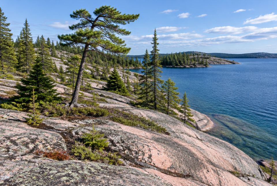 Typical Canadian Shield: very old rock smoothed by glaciers, thin soil, evergreen trees and lots of lakes. AI-generated imageHow glaciers shaped the Shield, not to scale: (1) soil on top of rock, (2) a moving glacier scrapes the soil away and digs hollows, (3) bare rock, thin soil, and hollows that fill with water to make lakes.
Working on the Shield
The rock and water are full of natural resources:
- Mining: nickel and copper (around Sudbury), gold (around Timmins), iron ore (in Labrador) and diamonds (in the Northwest Territories).
- Forestry: trees from the boreal forest become lumber and paper.
- Hydroelectricity: rivers rushing over rock are used to make electricity. Quebec and Manitoba make most of their electricity this way.
- Tourism: canoeing, fishing, camping and cottages, in places like Algonquin Park.
Thin soil and rock make farming hard, so there are fewer farms and fewer big cities. Cities include Sudbury, Thunder Bay and Yellowknife.
Peoples of the Shield
Many First Nations and Inuit live on the Shield today, including Anishinaabe (such as Ojibwe and Algonquin), Cree, Oji-Cree, Innu (in Quebec and Labrador) and Dene (in the Northwest Territories, Saskatchewan and Manitoba). Inuit live in the far north of the Shield, in Nunavik (northern Quebec), Nunatsiavut (Labrador) and Nunavut.
For example, the Cree of Eeyou Istchee (the James Bay area of Quebec) signed the James Bay and Northern Quebec Agreement in 1975, together with Inuit of Nunavik, after big hydroelectric dams were planned on their land. It is called Canada's first modern treaty.
The Hudson Bay Lowlands: flat and wet
Where: a wide band of land along the south-west shore of Hudson Bay and James Bay, mostly in Ontario and Manitoba.
Land: very flat and low, with slow rivers. Water can't drain away well, so much of it is muskeg: bogs and wetlands covered with moss. It is one of the biggest wetlands in the world. Farther north, there is permafrost.
Climate: long, very cold winters and short, cool summers. Cold winds blow off Hudson Bay, which is frozen for much of the year.
Vegetation and wildlife: mosses, shrubs and small, thin trees like black spruce. Millions of geese and other birds nest here in summer. Polar bears live along the coast, and beluga whales gather in river mouths near Churchill, Manitoba in summer.
Living in the Lowlands
Few people live here. Most communities are Cree First Nations, such as Moose Cree First Nation, Attawapiskat, Fort Albany and Peawanuck (Weenusk First Nation) in Ontario. The towns of Moosonee (Ontario) and Churchill (Manitoba) are here too.
- Few roads: people travel by plane, train (to Moosonee and to Churchill), boat, or winter roads over frozen land.
- Jobs include hunting, fishing and trapping, work in schools, health centres and stores, tourism (visitors come to Churchill to see polar bears) and some mining exploration (searching for minerals).
- The wet ground is too soft and cold for farming, and the growing season is short.
Just for funSome rock on the Canadian Shield is about 4 billion years old. If rocks had birthday parties, they would need a LOT of candles!
| Canadian Shield | Hudson Bay Lowlands |
|---|
| Land | Rocky, old, many lakes, thin soil | Flat, low, wet (muskeg) |
| Climate | Cold winters, warm summers in the south | Long, very cold winters; short, cool summers |
| Vegetation | Boreal forest | Mosses, shrubs, small trees |
| Main activities | Mining, forestry, hydroelectricity, tourism | Hunting, fishing, trapping, services, some tourism |
Worked exampleLet's explain a pattern
Why does the Canadian Shield have so many mines but so few farms?
- Look at the rock: the Shield is very old, hard rock, and minerals like nickel, copper and gold are found in it.
- Look at the soil: glaciers scraped most of it away. What is left is thin and rocky.
- Farms need deep soil. Mines need minerals in rock.
The Shield's rock is rich in minerals (good for mines), but its soil is thin (bad for farms).
Worked exampleLet's think like a traveller
You want to visit Attawapiskat from Toronto in August. There is no all-season road. How could you get there?
- In summer, the winter roads have melted, so you can't drive.
- You could take a plane. Many northern communities have an airport.
- Or you could take a train to Moosonee, then a plane or boat farther north.
Most likely by plane (the winter road only works when the ground and rivers are frozen).
Hands-on activityGlacier in a pan
You need: a baking pan, sand or soil, a few small pebbles, and an ice cube. A grown-up should be nearby. Keep pebbles away from small children.
- Spread a layer of sand in the pan and mix in a few pebbles. This is the land before the glacier.
- Press the ice cube (your glacier) onto the sand and push it slowly across the pan.
- Look: the glacier scrapes sand and pebbles along and leaves scratches and hollows.
- Let the ice cube melt in one hollow. Did a little lake form?
- Explain to a grown-up how glaciers made the Canadian Shield rocky, with thin soil and many lakes.
What to look for: Your child connects the scraped, uneven sand to bare rock and the meltwater puddle to the Shield's many lakes.
Your turn
1What is Canada's biggest physical region?
2What made the Shield's soil so thin and created so many lakes?
Glaciers scraped the soil away and dug out hollows that filled with water.
3Name two minerals mined in the Canadian Shield.
Any two: nickel, copper, gold, iron ore, diamonds.
Wet, boggy land covered with moss.
5Which large animals live along the coast of Hudson Bay?
Polar bears (and beluga whales in the river mouths in summer).
6How do people often travel to Hudson Bay Lowlands communities in summer?
By plane (also by train to Moosonee or Churchill, or by boat).
7Name one First Nation that lives in the Hudson Bay Lowlands.
Any one: Moose Cree First Nation, Attawapiskat, Fort Albany, Peawanuck (Weenusk First Nation). All are Cree.
More practice: warm-up
1What shape does the Canadian Shield make around Hudson Bay?
2What kind of forest grows on the Shield?
3Is the Hudson Bay Lowlands land hilly or flat?
4Name a city on the Canadian Shield.
Any one: Sudbury, Thunder Bay, Yellowknife, Timmins.
5Is it easy or hard to farm in the Hudson Bay Lowlands?
Hard. The ground is wet and cold, and summers are short.
More practice: on your own
1Why are Quebec and Manitoba able to make so much hydroelectricity?
The Shield has many rivers that rush over rock, with falls and rapids. That moving water can turn turbines to make electricity.
2What is a winter road, and why does it only work in winter?
A road built over frozen land, lakes and rivers. In summer the ice melts and the ground is wet muskeg, so trucks can't drive on it.
3Why do tourists visit Churchill, Manitoba?
To see polar bears (in the fall) and beluga whales (in summer).
4What was the James Bay and Northern Quebec Agreement?
An agreement signed in 1975 by the Cree and Inuit of northern Quebec with the governments, after hydroelectric dams were planned on their land. It is called Canada's first modern treaty.
5Compare the land of the Shield and the Lowlands in one sentence each.
Shield: old, hard rock with thin soil and many lakes. Lowlands: flat, low and wet, with muskeg.
Challenge
1Food in northern Lowlands communities often costs much more than in Toronto. Use what you learned to explain why.
There are few or no roads, so food must come by plane, train or winter road, which is expensive. The short, cold growing season and wet ground make farming there very hard, so most store food comes from far away.
2Hydroelectric dams make clean electricity, but they can flood land. Why might this be a big concern for First Nations and Inuit communities who live nearby?
Flooding can cover hunting and trapping grounds, homes, burial places and fishing areas, and change rivers that people have used for generations. That affects food, culture and way of life. That is why Cree and Inuit negotiated the James Bay Agreement.
3Explain how glaciers from long ago still affect jobs on the Shield today.
Glaciers scraped away soil, so farming is hard, but they left bare rock where minerals are easier to reach (mining), and thousands of lakes and rivers for hydroelectricity and tourism (canoeing, fishing, cottages).
Quiz
1. Which is Canada's largest physical region?
2. Why does the Shield have thin soil?
3. Which job fits the Canadian Shield best?
4. Wet, mossy, boggy land in the Hudson Bay Lowlands is called...
5. Most communities in the Hudson Bay Lowlands are...
6. Why can't trucks use a winter road in July?
Big idea: The Canadian Shield (old rock, lakes, boreal forest, minerals, hydroelectric power, thin soil) and the Hudson Bay Lowlands (flat wetlands, permafrost, few roads, mainly Cree communities) are physical regions that cross many provinces and territories. Their land and climate shape where people live, how they travel, and what work they do.
How to help at home:
- If you have been to a cottage, northern park or northern city, talk about the rock and lakes you saw.
- Look at a satellite map of northern Ontario or Quebec with your child. Count the lakes in one small area.
- Discuss why the same carton of milk might cost more in a fly-in community.
Common difficulties:
- Mixing up "lowlands" regions. The Hudson Bay Lowlands are wet and northern; the Great Lakes–St. Lawrence Lowlands are in the south with farms and cities.
- Thinking northern communities are "in the past". Communities have schools, health centres, stores and internet, and many people also hunt, fish and trap.
Safety: The glacier activity uses small pebbles; keep them away from young children.