B. People and Environments · The Local CommunityMaps, Symbols and Legends
B3.6 B3About 40 minutes
Learning goals- I can explain that a map shows a place from above.
- I can use symbols and a legend to read a simple map.
- I can use words like beside, above, below, left, right, near and far to tell where things are.
- I can measure distance on a map with non-standard units, like squares or steps.
- I can draw a simple map with my own symbols and a legend.
Words to know
map
A drawing of a place as if you were a bird looking down from above.
symbol
A small picture or shape that stands for a real thing on a map.
legend
A box on a map that shows what each symbol and colour means. It is also called a key.
location
Where something is.
distance
How far it is from one place to another.
route
The path you take to go from one place to another.
A bird's-eye view
Imagine you are a bird flying over your street. You look down. You would see the tops of houses, the roads like long ribbons, the green parks and the blue river.
A map is a drawing of a place from above, like a bird would see it. Maps help us find places and plan how to get there.
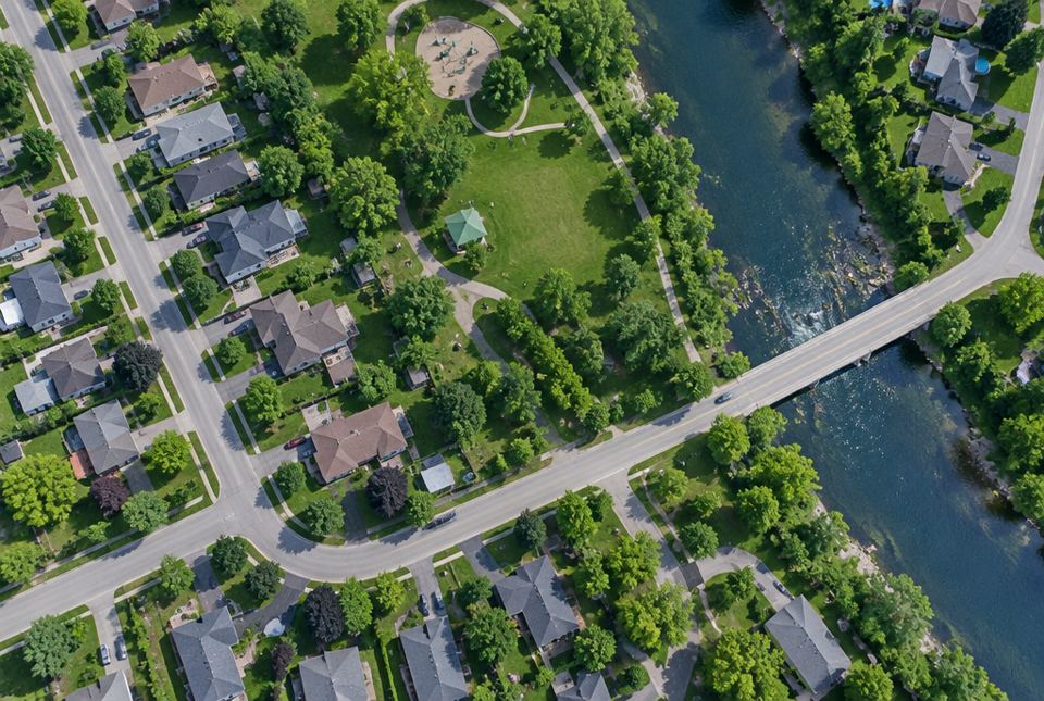 A bird's-eye view: you see the tops of houses, the roads, a green park and a river. A map shows a place from above like this. AI-generated image
Symbols and legends
Mapmakers can't draw every tiny detail. Instead, they use symbols. A symbol is a small picture or shape that stands for a real thing.
- A small house shape can stand for a house.
- A blue wavy shape can stand for a river.
- A green square can stand for a park.
The legend shows what each symbol means. Always read the legend first!
Location words
We use location words to tell where something is:
beside · next to · between · above · below · left · right · near · far · across from
On the map above:
- The river is on the left side of the map.
- The school is above the road.
- The park is below the road, between the river and two of the houses.
| Column 1 | Column 2 | Column 3 |
|---|
| Row 1 | 🌳 | 🏠 | 🏫 |
| Row 2 | 🚒 | 🛝 | 🏪 |
| Row 3 | 🌳 | 🏥 | 📚 |
How far is it?
We can measure distance on a map without a ruler. We can count squares, or count our steps on a real walk, or use paper clips or blocks. These are called non-standard units.
In the grid map below, each square is 1 step. Count the squares to find how far it is from one place to another.
Worked exampleExample: Let's read the grid map
How far is it from home (H) to school (S)? Then, which is closer to the school: the library (L) or the park (P)?
- Put your finger on H. Move right one square at a time to S and count: 1, 2, 3, 4, 5. Home to school is 5 squares.
- From S to L: move right and count 1, 2, 3, 4. That is 4 squares.
- From S to P: move down and count 1, 2. That is 2 squares.
- Compare: 2 is less than 4, so the park is closer.
Home to school is 5 squares. The park (2 squares) is closer to the school than the library (4 squares).
Worked exampleExample: Make a map with your own symbols
Mira wants to map her bedroom. She has a bed, a desk, a window and a toy box.
- Look from above. She pretends she is on the ceiling looking down.
- Choose symbols. A long rectangle for the bed, a small square for the desk, a line on the wall for the window, a circle for the toy box.
- Draw each symbol where the thing really is. The bed goes against the wall, the desk under the window.
- Make a legend in the corner showing each symbol and what it means.
Mira's map has symbols and a legend, so anyone can read it.
Just for funWhat if maps had no legend? You might think the little house symbol was a giant birdhouse, and the wavy blue river was a very long, sleepy snake!
That's why we always read the legend first.
Hands-on activityMap my room (or my street)
You need: paper, a pencil, crayons and small toys or blocks.
- Build it first: use blocks or toys on the floor to make a model of your room. Stand up and look down at it, like a bird!
- Draw it: draw the room from above. Use simple symbols (shapes) for the bed, door, window and other things.
- Legend: draw a box in the corner. Put each symbol in the box and write what it means.
- Measure: count how many of your steps it takes to walk from your bed to the door. Write it on your map.
- Test it: hide a small toy, mark it with an ✖ on your map, and ask someone to find it using your map!
Your turn
1A map shows a place from... the side or above?
Above, like a bird looking down.
2What is a symbol on a map?
A small picture or shape that stands for a real thing.
3Look at the community map. How many houses are there?
4 houses. Count the house symbols: 2 above the road and 2 below the road.
4Look at the community map. Is the school above or below the road?
5In the picture grid, what is to the right of the playground?
6In the grid map, how many squares is it from school (S) to the library (L)?
7Why does a map need a legend?
So people know what each symbol and colour means.
More practice: warm-up
1In the picture grid, what is above the playground?
2In the picture grid, what is below the playground?
3On the community map, is the river on the left side or the right side?
4What is another name for a legend?
5Name a non-standard unit you could use to measure your hallway.
Examples: your steps, your feet, blocks, paper clips, shoes.
More practice: on your own
1On the community map, what is between the river and the two houses below the road?
2In the picture grid, which two things are in the corners on the left side?
Two trees 🌳 (Row 1, Column 1 and Row 3, Column 1).
3On the grid map, how far is it from home (H) to the library (L)? Explain.
9 squares. Home to school is 5, and school to library is 4. 5 + 4 = 9.
4Make up a symbol for a hockey arena. Tell why you chose it.
Answers will vary. Example: "A hockey stick inside a rectangle, because people play hockey at the arena." A good symbol is simple and reminds you of the real thing.
5Ali walks 20 steps to his mailbox. Jo walks 35 steps to hers. Whose mailbox is farther from their door?
Jo's. 35 steps is more than 20 steps.
Challenge
1Kit's legs are long and Ben's are short. They both count steps to the park. Who will count more steps? Why?
Ben, because his steps are shorter, so he needs more of them to go the same distance. That's why the same unit is important when we compare.
2On the grid map, describe a route from home to the park using the words right and down.
Go right 5 squares to the school, then down 2 squares to the park. That is 7 squares in all.
3Why do you think maps use simple symbols instead of drawing every detail?
Simple symbols keep the map clear and easy to read. If every leaf and window were drawn, the map would be too crowded.
Quiz
1. A map shows a place from...
3. On the community map, how many houses are there?
4. On the community map, where is the school?
5. On the grid map, how many squares is it from school (S) down to the park (P)?
6. Which is a non-standard unit?
7. A blue wavy line on a map most likely stands for...
Big idea: Maps show places from above using symbols, colours and a legend. Grade 1 students read and build simple maps of familiar places, use relative location words (beside, above, below, left, right, between, near, far) and measure distance with non-standard units.
How to help at home:
- Build a model of a room with toys, then draw it from above.
- On walks, count steps between landmarks ("It's 40 steps to the stop sign!").
- Look at a real map together (a mall directory, a park trail map, a transit map) and find the legend.
Common difficulties:
- Drawing from the side. Children often draw a side view. Have them stand on a sturdy chair (safely, with you) and look down at a toy layout.
- Left and right. Use a sticker or bracelet on one hand to help.
- Comparing different units. Two people's steps are different sizes, which is the reason we later use rulers and metres.